David Chandler Plastic Planisphere Star Charts


David Chandler Plastic Planisphere Star Charts
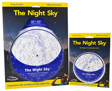
Size Option
Latitude Zone
Why Purchase from All-Star Telescope?
Free Expert Support
Whether you are a first timer needing help with setting up or an enthusiast that can't quite make that one thing work, our expert staff are ready to support your needs. With decades of knowledge and first hand experience we've been there and we can help you through it!
Stress Free, Secure Transactions
You can trust purchasing and delivery with All-Star Telescope. All of our transactions are 100% secure and Level 1 PCI DSS compliant thanks to Shopify's ShopPay platform. For additional protection, we insure 100% of the value of every shipment we make. If it get's lost during shipment, we replace it. If it gets damaged during shipment, we repalce it. We make sure your product arrives exactly as you would expect it to; we promise.
We also ensure privacy protection. We never keep any of your credit card information on file and any of your personal data is stored accordign to our policies.
30 Day Return Policy
Buy with confidence knowing that we accept returns up to 30 days after purchase. We want you to have something you will actually use and we are confident that we keep good quality products in our store with No Junk.
Price Match Promise
Shipping around for the best price is tough, we make it easier by offering the best pricing in the market. But if you find a better price on an in-store item somewhere else we will match it!
Product Description
Latitude Ranges
Planispheres are produced for specific latitudes because the portion of the sky you will be able to see depends on where you are on the Earth. The farther north you are, the more of the northern hemisphere stars you will be able to see but the horizon will block more of the southern hemisphere. We produce our charts in more different latitude versions than any other major chart.
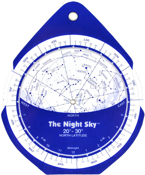
The Night Sky is NOT a conventional planisphere! No flat map can remove all distortion, but with its pioneering two-sided design The Night Sky eliminates over 90% of the distortion inherent in conventional one-sided planispheres.
Be sure to select the correct latitude version for your observing location to get the most accurate representation of the sky above. If you need assistance determining your latitude click here for a selector map.
We carry Latitude Ranges from 20° N to 60° N, as well as a Southern Hemisphere option. Each option comes in both a Large (10" x 8.5") and Small (6" x 5") Size. See below for Latitude Selector map.
The Distortion Solution
The map projection used for any planisphere is a flat representation of our spherical view of the cosmos. Some distortion of distance, scale, area, etc. always results from this process. In map projections commonly used in planispheres this distortion increases geometrically as distance from the center increases. In conventional planispheres the distortion can be extreme which makes for a confusing and difficult to use star chart. This distortion results from trying to stretch the whole dome of the sky onto a single flat map.

The Night Sky is NOT a conventional planisphere! Our unique two-sided planisphere has been in print for over 35 years and no chart is more respected or recommended. No flat map can remove all distortion, but by displaying half of the sky on the front and the other half on the opposite side The Night Sky eliminates over 90% of the distortion inherent in conventional one-sided planispheres. Although The Night Sky is the choice of professionals worldwide, beginners of all people, need clear, accurate, and reliable observing aids.
The Night Sky™ is Designed to be Used!
- Unlike coffee-table planispheres, The Night Sky is printed with dark stars on a light background, for easy nighttime readability.
- The constellations are drawn simply, emphasizing the brighter stars which makes them easy to recognize and locate with the naked eye or entry level equipment.
- Coordinate grid lines are shown without being intrusive. Coordinates are shown because they can be useful for cross referencing with star atlases.
- A selection of deep sky objects for binocular viewing is included. It is important to point out to beginners that the best first telescope is a pair of binoculars. You may already have what it takes to start observing tonight!
- The Night Sky is larger than it looks! The map scale is larger than on similar-size planispheres because the whole sky does not have to be shown on a single map. Even the 5″ pocket version is large enough to be quite readable.
The Night Sky™ is widely recognized by the amateur astronomy and educational communities as the overall best planisphere on the market.
Who Will Find The Night Sky™ Useful?
The Night Sky™ is perfect for anyone who wants to recognize the constellations, whether for naked-eye viewing, or to help find things with binoculars or a telescope. Beginners will find it is the best way to learn the sky. It shows not only what to look for, but where and when. Students can use it as a miniature planetarium, to help understand the motions of the sky. Telescope users will find that The Night Sky™ is a fantastic overview map to use as the perfect complement to our Sky Atlas for Small Telescopes and Binoculars™. Amateur astronomers can use it to plan observing events. It shows what will be visible on any day, any time of night.
Latitude Selector Help Map
